
As a self-confessed packrat I more than occasionally come across items that I never knew (or totally forgot) I had. This is exactly what happened a few days ago--but a brief detour for some background photos is necessary.
My maternal grandparents, Everett and Ruth Carpenter, lived in a house in Cumberland, Rhode Island that was inherited by my grandfather. The house had been in the Miller/Carpenter family since about 1767 when it was built by Peter Miller, my 5X great grandfather. My mother and her two siblings grew to adulthood in the house and I have good memories of the house and property from my many visits during my youth.
Below are photographs of what the Miller/Carpenter homestead looked like at various stages before 1957. Notice the trees that are located in front of the house in all the photos, which pre-date 1957. After a road widening project in 1957-58, those trees and the picket fencing no longer existed. Also, the first three photos show a tall chimney at the back of the house which is where the kitchen was located. In the fourth photo, taken from the rear of the house, the chimney is missing because it blew down in the infamous 1938 hurricane. Only the third photo gives a glimpse of the barn, which is the structure in the background behind the kitchen of the house. The barn survived the 1938 hurricane, but it was a lot worse for the wear by that terrible storm and as children my siblings and I were not allowed onto the upper floor or even into the barn without and adult with us. The house and barn and the few acres they sat on were located at what was known as 551 High Street in Cumberland. [See, "This Old House" Feb. 8, 2013]


Below are photographs of what the Miller/Carpenter homestead looked like at various stages before 1957. Notice the trees that are located in front of the house in all the photos, which pre-date 1957. After a road widening project in 1957-58, those trees and the picket fencing no longer existed. Also, the first three photos show a tall chimney at the back of the house which is where the kitchen was located. In the fourth photo, taken from the rear of the house, the chimney is missing because it blew down in the infamous 1938 hurricane. Only the third photo gives a glimpse of the barn, which is the structure in the background behind the kitchen of the house. The barn survived the 1938 hurricane, but it was a lot worse for the wear by that terrible storm and as children my siblings and I were not allowed onto the upper floor or even into the barn without and adult with us. The house and barn and the few acres they sat on were located at what was known as 551 High Street in Cumberland. [See, "This Old House" Feb. 8, 2013]


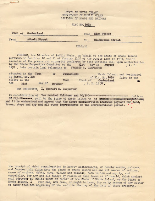
On August 21, 1957, the Director of Public Works (Joseph M. Vallone) wrote on behalf of the State of Rhode Island and Providence Plantations to give legal notice that the State Properties Committee had authorized by condemnation the acquisition of some of my grandparents' property. The acquisition was one of many such condemnations and acquisitions along High Street between Abbott Street and Blackstone Street for the purpose of widening and improving High Street.

On December 27, 1957, a letter from the Rhode Island Department of Public Works, Division of Roads and Bridges, was addressed to Sarah E. Carpenter, the mother of my grandfather, Everett S. Carpenter. The letter from Joseph S. Garside, Right-of-Way Engineer, was intended to inform my great grandmother that a portion of her property at 551 High Street was being taken for highway purposes and that it had been appraised at $213.00 to fully settle all claims she might have. [There clearly had been some error in the land records search, however, because Sarah E. Carpenter (1858 - 1945) had been dead for more than twelve years as of the date of the letter.]

By August 13, 1958, the correct ownership of 551 High Street had been resolved and the consideration for the condemnation of a portion of my grandfather's property at 551 High Street had been settled for the appraised value of $213.00. Both my grandfather and my grandmother signed a modified release (including any right to dower in the condemned property my grandmother may have had). The release was witnessed by D. Thomas Auello.


So, all of the above might be very interesting for the parties involved, including the state officials named in the various documents, but what does this really have to do with genealogy other than for the Carpenter family and perhaps the families of the named state officials? Well, when a condemnation of private property occurs for a public use there needs to be just compensation for the property taken and it is based on an appraisal process. When a large number of properties are affected there is almost always a plat done to show the location and extent of the subject property(s) and the portion(s) to be taken. As the initial notice of the legal taking shown above indicates, the notice to all affected property owners had a plat that accompanied the notice.
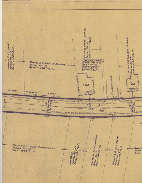
For the entire highway improvement project on High Street from Abbott Street north to Blackstone Street six plats were required to show the entire route and the properties affected by the takings and improvements. The plat that was sent to my grandparents and to eighteen other land owners in the immediate neighborhood was Plat No. 1014 (which was the sixth of the six plats showing the project along High Street from Abbott to Blackstone). The scale of the plat is 40 feet per inch and for each individual property shown the dimensions of the property being condemned and taken for public use is given along with the name(s) of the property owner(s). The portion of Plat 1014 that shows the Carpenter property is provided immediately below.

The Carpenter property was the larget property of all the properties shown for the section of High Street covered by Plat 1014. The Carpenter property was designated as Parcel 124 and the plat shows that the strip of Carpenter land fronting High Street that was to be taken was 540 ft. more or less. The above portion of Plat 1014 also shows the location of Parcels 122 and 123 across High Street from the Carpenter property and it indicates who the owners of the property were--John Tyson for Parcel 22 and Andrew J. & Jane B. Pascale for Parcel 123.
The remaining properties on Plat 1014 are shown below and the names of the owners and the square footage of the land being taken by the condemnation is provided for each property shown.


Sixty-three years after the takings along High Street in Cumberland there are probably very few property owners who are the same owners (or descendants of the 1957 owners) and so the plats for the highway improvements done along High Street going on seven decades ago can be considered source information for genealogical purposes. And to that end, and because the printing in the above images may be somewhat dificult to make out, a full list of the property owners on Plat 1014 is shown below in the hope that it might be of some use for those researching ancestors who lived in Cumberland in the late 1950s.
The list of property owners shown on Plat 1014 begins at the intersection of High and Blackstone Streets just north of the Carpenter property and proceeds on the eastern side of High Street southward and then lists property owners on the west side of HighStreet beginning at the south end of the plat proceeding northward back to Blackstone Street.
East Side of High St. South of Blackstone St.
Parcel No. 125 -- Chester T. Pollett et al.
Parcel No. 124 -- Sarah E. Carpenter
Parcel No. 121 -- William Ball
Parcel No. 120 -- Wallace & Elsie Driesner
Parcel No. 115 -- Simon P. & Alice G. Breen
Parcel No. 114 -- Wallace & Elsie Driesner
Parcel No. 113 -- Hugh Ward
Parcel No. 112 -- Wilfred O. & Alice Sylvestre
Parcel No. 108 -- James A. & Alice T.E. Broadbent
[A dwelling marked #487, owner(s) and parcel number must be on Plat 5 of 6]
West Side of High St. North to Blackstone St.
Parcel No. 105 -- Joseph & Florence Rentes
Parcel No. 109 -- Antonio P. Rezendes
Parcel No. 110 -- Manuel F. & Maria F. Martins
Parcel No. 111 -- Walter & Nancy Cowdell
Parcel No. 116 -- Francis J. & Elizabeth A. Burns
Parcel No. 117 -- Robert & Mary I. Rayley
Parcel No. 118 -- Ida M. & Joseph P. Bradley
Parcel No. 119 -- Daniel E. & Mary Corcoran
Parcel No. 122 -- John Tyson
Parcel No. 123 -- Andrew J. & Jane B. Pascale.
_ _ _ _ _ _ _ _ _ _ _ _ _ _ _ _
Eminent domain image from Debate.org at https://www.debate.org/opinions/is-eminent-domain-a-fringe-upon-rights.
All other images from original documents in the collection of the author.
_ _ _ _ _ _ _ _ _ _ _ _ _ _ _ _
Copyright 2020, John D. Tew
_ _ _ _ _ _ _ _ _ _ _ _ _ _ _ _
This comment has been removed by a blog administrator.
ReplyDelete